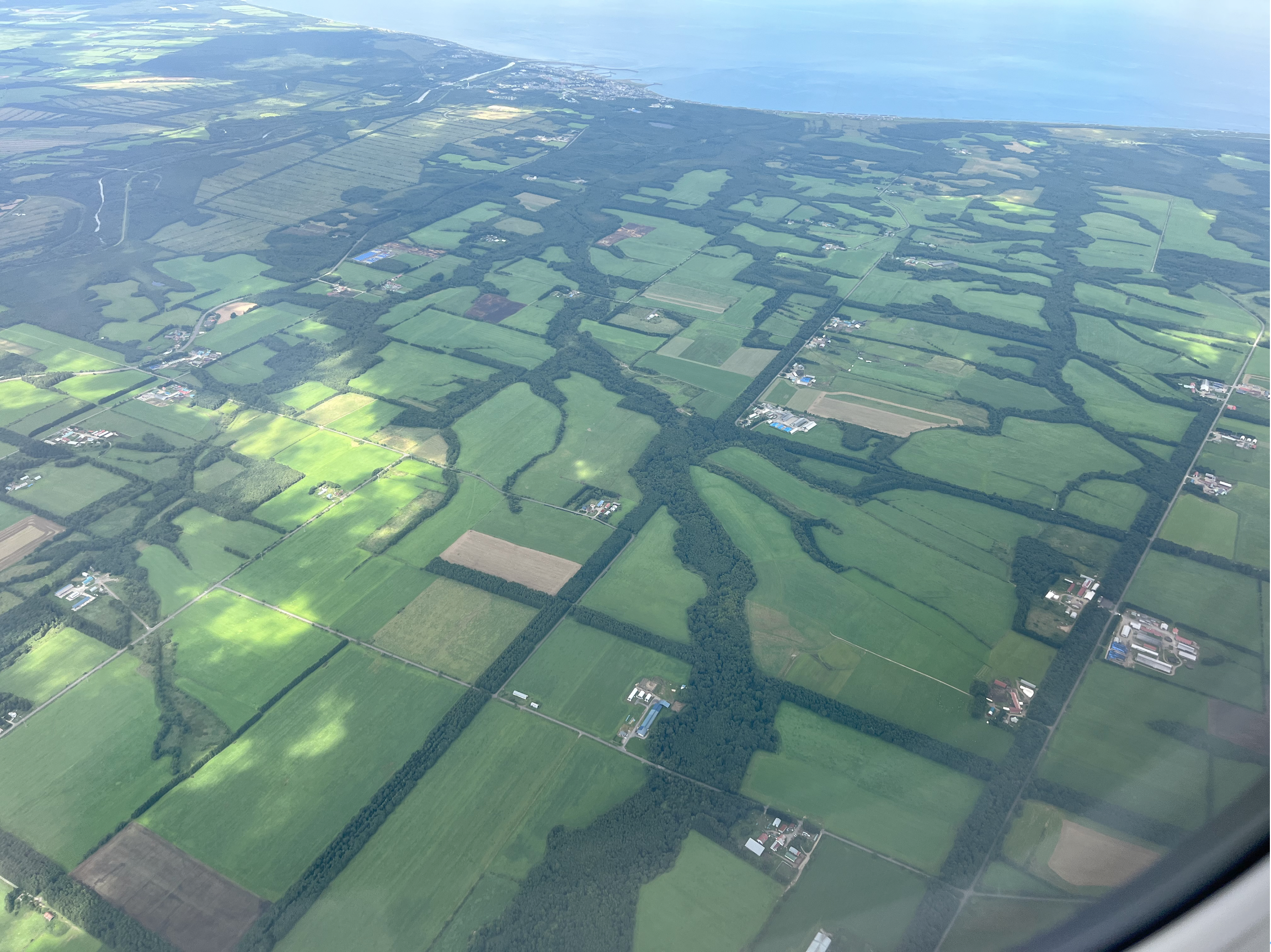
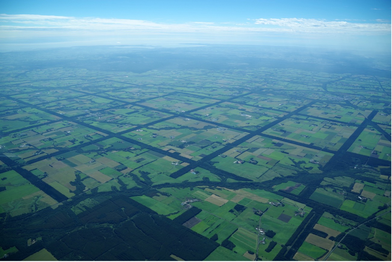
Stretching across four municipalities in eastern Hokkaido—Nakashibetsu, Betsukai, Shibetsu, and Shibecha—the Konsen Plateau is the largest plain in Hokkaido. The grid-pattern windbreak forests that spread across this plateau are perhaps the only example of a cultural landscape created through human intervention in nature that can be clearly recognized even from outer space.
In Nakashibetsu Town, located near the center of the plateau, a survey was conducted soon after the 2004 revision of the Law for the Protection of Cultural Properties introduced the cultural landscape designation system. Under the title “Preservation and Utilization Project of the Grid Windbreak Forests of Nakashibetsu,” the study was carried out with the aim of future designation, and a report was published in 2006. However, at that time, local consensus could not be reached, and the application for designation was deferred.
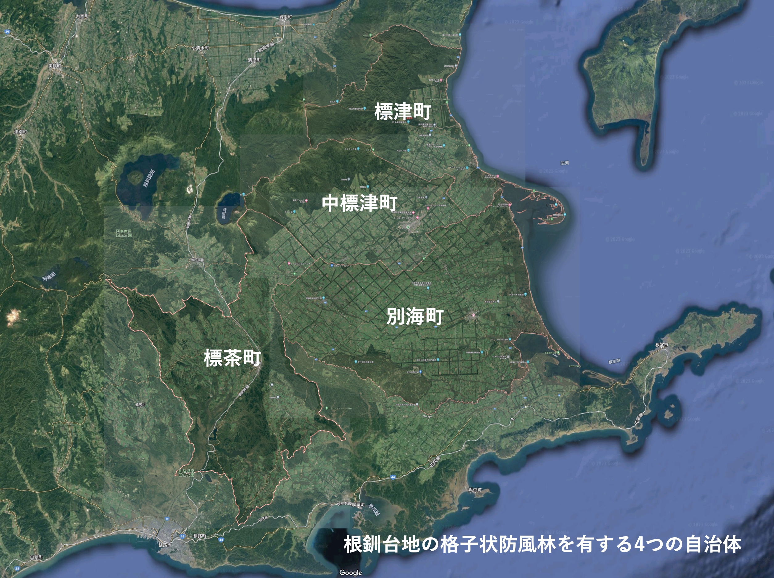
Nearly twenty years later, momentum is once again building in Nakashibetsu Town toward the preservation and utilization of the grid windbreak forests, spurred by the Agency for Cultural Affairs’ recognition of the town’s Cultural Property Conservation and Utilization Plan. In response, the town has reached out to the other three municipalities of the Konsen Plateau, and together they have formed a voluntary association—the Society for the Selection of the Grid Windbreak Forests and Dairy Farming Landscape of the Konsen Plateau as an Important Cultural Landscape. The aim of this initiative is the comprehensive preservation and utilization of the grid windbreak forests.
As I participate in this ambitious effort, I have identified three stories that, in my view, reveal the appeal and significance of these forests.
What first astonished me was the origin of the grid-patterned forests. I had long believed that the Konsen Plateau was once a vast open land—grasslands and wetlands—and that, at a certain point, trees were planted in a grid formation to create the landscape we see today. In fact, this was not the case. The grid pattern emerged as settlers cleared patches of the primeval forest, cutting down the existing trees to open rectangular parcels of farmland and residential land.
Relying only on the colonial district layout plans brought from various settlement areas, they began land reclamation, and it took roughly a century for the present landscape to emerge. In other words, the grid-like forest was originally primeval forest itself; the “figure” and “ground” that I had imagined were completely reversed.
Although the windbreak forests were created in this manner, they later became managed as national forests under forestry operations. As a result, some areas were clear-cut and replanted in orderly rows with a single tree species. Yet in other areas, remnants of the original primeval forest remain—dense groves, old trees, even giant trees—and within them, diverse ecosystems continue to thrive, as local researchers have pointed out.
Behind the artificial grid design lies an unexpected richness: landscapes of forest that defy the geometry, and the breath of countless plants and animals. This striking contrast between appearance and reality is something that has drawn me deeply to these forests.
When viewed from above, the grid-patterned windbreak forests easily call to mind the checkerboard layout of Kyoto or the blocks of New York, leading one to assume that local communities developed according to the rectangular units of the grid. In reality, however, this was not the case. Beginning in the early 20th century, settlers arrived in groups from various parts of Japan, bringing with them ties of local kinship and community. They were placed not according to the designed grid, but in more organically defined parcels of land.
Each settlement carried with it the cultural practices and beliefs of its place of origin—whether from Tōhoku, Kyushu, or elsewhere—so that even neighboring villages displayed strikingly different ways of life, festivals, food traditions, and landscapes. These communities referred to each other as “xx-shigai” (districts), growing through mutual support as well as competition. The legacy of that era can still be found today, preserved within the communities nestled among the grid windbreak forests.
Until the Meiji era, most of Hokkaido was still covered by primeval forests. On the Konsen Plateau in eastern Hokkaido, the grid windbreak forests—sometimes referred to as the great green grid—represent a cultural landscape that has evolved organically through more than a century of reclamation and dairy farming, today covering an area of approximately 200,000 hectares. The vision was grand: to carve 100-ken-wide (about 180 meters) windbreaks out of the primeval forest, forming a grid of squares, within which farmland and homesteads were established and protected.
Settlement of the Konsen Plateau began later than in other parts of Hokkaido. Based on the advice of Horace Capron, an American engineer invited to Japan as a government advisor in the 1870s, Shosuke Sato led the planning effort, and the Hokkaido Government initiated colonization in the early 20th century using its standardized district layout.
More than 120 years after these districts were first established, the Konsen Plateau—spanning the neighboring towns of Nakashibetsu, Shibecha, Shibetsu, and Betsukai—remains the only area where these colonial layouts have been preserved as a contiguous whole, allowing us to clearly discern their historical layers. The grid windbreak forests extend up to 27 kilometers in length, with a total length of 648 kilometers and an area of 15,708 hectares, continuing to protect both daily life and the agriculture—particularly dairy farming—that forms the backbone of the region.
This landscape was neither created all at once nor spread outward from a single point. Instead, multiple waves of settlers advanced simultaneously into different parcels of land, extending toward the northern mountains including Mount Shibetsu and the Shiretoko range. Over time, these efforts became interconnected. Even lands initially excluded from colonization due to their difficulty were eventually opened for reclamation in the latter half of the 20th century. In the final quarter-century, with the spread of agricultural machinery, the grid windbreak forests and riparian woodlands came to stand out distinctly in the landscape, framing the dairy-based farming system that defines the Konsen Plateau today.